17.8.09

TOURISM IN LIBYA


Introduction
Libya is home to a mesmerizing variety of archaeological cultures and remains that range from the Paleolithic to Byzantine times. The third largest of the African nations, most of its landmass is covered by that great “sea of sand” the Sahara Desert. Breathtakingly skillful late Pleistocene depictions, of long vanished fauna and the early Olocene pastoralists who hunted them, are found on the open-air rock shelters located deep in the desert. The native Berber Libyan peoples familiar to Herodotus and the Roman historians have left us vivid traces of their enigmatic religion and rural existence in remote sites like Slonta and Ghirza. In historical times coastal Tripolitania and Cyrenaica were occupied by waves of Carthaginians, Greeks, Romans and Byzantines. Today their artistic and artifactual remains are beautifully exhibited in the Museum of the Jamahiryia located in Tripoli’s Assai al-Hamra, or “Red Castle.” While most students and enthusiasts of Classical civilization may be familiar with Leptis Magna, Sabratha and Cyrene, if only by name, out-of-the-way places like Silin, Zliten, Te uchira, Ptolemais, Apollonia, Gasr Lebia and Al-Atrun will fascinate even the seasoned traveler.

Libya presents the opportunity to visit a country rich in archeological and scenic treasures, yet little known and exploited by mass tourism.
On the Mediterranean Coast, you can visit the stunning ruins of the Roman cities of Leptis Magna, Sabrata as well as that of the Greek city of Cyrene. These ruins are considered by historians to be the most impressive and best preserved examples of Roman and Greek civilization in all of North Africa.
Inland, those inspired by desert travel have the great Sahara; towering sand dunes stretching out to the horizon, the oases, and the desert people, the Tuareg, living as much as they always have.
For those interested in World War II history, a visit to Tobruk is a must.
And all over Libya you will find the authentic warmth and hospitality for which Libya is well known.


We, at Tourism Services Blog hope that you will have the chance to experience these things for yourself.

LIBYAN DESERT


The Libyan Desert (24 degrees North, 25 degrees East)is located in the northern and eastern part of the Sahara Desert. It occupies Egypt west of the Nile (hence the term 'Western Desert' to describe its Egyptian portion), eastern Libya and northwestern Sudan alongside the Nubian Desert. Covering an area of approximately 1,100,000 square kilometers, it extends approximately 1100 km from east to west, and 1,000 km from north to south, in about the shape of a rectangle. Like most of the Sahara, this desert is primarily sand and hamada or stony plain.

Sand plains, dunes, ridges and some depressions (basins) typify the region, and no rivers drain into or out of the area. The desert's Gilf Kebir Plateau reaches an altitude of just over 1000 meters. and along with the nearby massif of Jebel Uweinat, is an exception to the uninterrupted territory of basement rocks covered by layers of horizontally bedded sediments, forming a massive sand plain, low plateaus and dunes.

There are eight depressions in the eastern Libyan Desert, and all are considered oases except the smallest, Qattara, because its waters are salty. Limited agricultural production, the presence of some natural resources, and permanent settlements are found in the other seven depressions, all of which have fresh water provided by the Nile or by local groundwater.

The Siwa Oasis, close to the Libyan border and west of Qattara, is isolated from the rest of Egypt but has sustained life since ancient times. Waw an Namus in the very centre of Libya, is an extinct volcano with reed-filled pools in its crater but no cultivation or habitation. The other major oases include Dakhla and Kharga in Egypt, and Jaghbub and Kufra in Libya. Apart from Kufra they form a topographic chain of basins extending from the Al Fayyum Oasis (sometimes called the Fayyum Depression) which lies sixty kilometers southwest of Cairo, south to the Bahariya, Farafra and Dakhla oases before reaching the country's largest oasis, Kharga Oasis. A brackish lake, Lake Karun, at the northern reaches of Al Fayyum Oasis, drained into the Nile in ancient times. For centuries sweetwater artesian wells in the Fayyum Oasis have permitted extensive cultivation in an irrigated area that extends over 2,100 square kilometers.

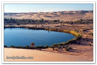
Lakes in Libyan Desert{AUM AL MAAH, GABER AOUN, AUM AL HISAN, TRUNA LAKE}


AKAKUS MOUNTAIN


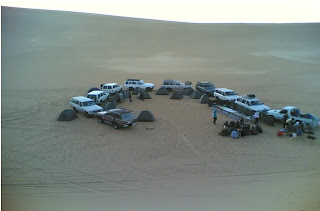
TOURISTS GROUP IN THE DESERT


LIBYAN BEACHES


There is no doubt that Libya is lined with some stunning beaches.
Libya overlooks the Mediterranean Sea with a coast line around 2.000 km long. This makes Libya's resort beaches among the longest along the Mediterranean Sea. Libya's beaches are characterized by variations in their natural appearances from sandy beaches under the shadows of palm trees to rocky beaches overlooked from above by great hills, such as the one that enjoyed at the Green Mountain Sea Resort.


Beach of ALJURF


Al Jurf beach lies along the Mediterranean coast, ( 3 km) from Sabratha, to the north west and extends for 2-3 km) where it is bordered by Sabratha park ( eastern part) on the south , separated by the tarmac road. It is 0-10 metres above sea level and belongs to the Sabratha and Surman populate Tillil conference.

Tourism importance:

It is a major tourist area along the Libyan coast, where visitors can stop for more than two days to view
Attractions such as:
1. Heritage features:
A) The archeological city of Sabratha, dated to the Phoenician and Roman era.
2. Natural features:
A ) Sabratha national park (western and eastern section). The eastern part lies along the beach. To the south is a pine forest popular with visitors, especially in spring.
B )Beaches: Sabratha’s pure sandy beaches stretch to the east and west; the best and most attractive is Tillil beach, where many people go in summer. A rocky beach, gradually rising above sea level 0-10 m. Its pure water can be used for thalassotherapy.

Infrastructure and basic services :

1. Roads: the beach lies directly along the coastal road, separated by a few metres that gradually widens westwards to Tillil beach.
2. Electricity: Electricity lines, to the guest house on AlJurf beach. .
3. Water: Mains water in the guest house on the shore.
4.Communications: several communication offices, and a local network (3km) to the shore.
5. Health services:
Tillil polyclinic ( 2km) to the west and Sabratha hospital (4 km)
6. Police stations: In Sabratha (3km)
7. Shopping centres: various shops in Sabratha.